DAVAO CITY (MindaNews / 18 Dec) – As Tropical Depression Onyok accelerated and moved closer to Surigao del Sur-Davao Oriental, a total of 23 out of Mindanao’s 27 provinces have been placed under Public Storm Warning Signal no. 1 as of 10 a.m. Friday, with the addition of four more provinces to the 19 listed at 5 a.m.
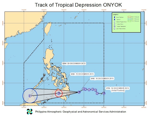
According to the Severe Weather Bulletin (SWB) No. 7 issued by the Philippine Atmospheric, Geophysical and Astronomical Services Administration (PAGASA) at 11 a.m., Onyok’s center was estimated at 265 km East Southeast of Hinatuan, Surigao del Sur or at 270 km East Northeast of Mati City, Davao Oriental with maximum winds of 55 kph near the center and forecast to move west at 20 kph.
 Onyok’s path. Source: PAGASA Severe Bulletin No. 7 issued at 11 a.m. on December 18, 2015
As of 11 a.m. Friday, according to PAGASA’s hourly update on Onyok, the Tropical Depression was at 255 km east northeast of Mati City in Davao Oriental.
Estimated rainfall amount is now “from heavy to intense within the 150 km diameter of the Tropical Depression,” compared to earlier estimates of “from moderate to heavy within the 100 km diameter” of Onyok.
Residents in low-lying and mountainous areas of the provinces with Public Storm Warning Signals are alerted against possible flashfloods and landslides.
By Saturday morning, Onyok is expected to be over Illana Bay or at 65 km West of Cotabato City and by Sunday morning, at 615 km West of Zamboanga City, as a Low Pressure Area (LPA), SWB 7 said.
In SWB No. 6 issued at 5 a.m., Onyok was supposed to be expected to be in the vicinity of Agusan del Sur and on Sunday, 230 kms south southeast of Puerto Princesa City as a low pressure area.
Only four Mindanao provinces have been spared, as of SWB 7: the island provinces of Basilan, Sulu and Tawi-tawi and Sarangani province.
Public Storm Warning Signal No. 1 has been raised over 23 provinces in Mindanao’s six regions:
Caraga Region: Surigao del Sur, Surigao del Norte (including Siargao Island), Dinagat Province, Agusan del Norte and Agusan del Sur;
Region 9 (Zamboanga Region or Western Mindanao): Zamboanga del Norte, Zamboanga del Sur and Zamboanga Sibugay;
Region 10 (Northern Mindanao): Bukidnon, Camiguin, Lanao del Norte, Misamis Oriental and Misamis Occidental;
Region 11 (Davao Region or Southeastern Mindanao): Compostela Valley, Davao Oriental, Davao del Norte, Davao del Sur, and the northern part of Davao Occidental;
Region 12 (Soccscksargen or Southwestern Mindanao): North Cotabato, Sultan Kudarat, northern part of South Cotabato; and
Autonomous Region in Muslim Mindanao: Lanao del Sur and Maguindanao.
The public and the disaster risk reduction and management councils are advised to take appropriate actions.
Under PSWS 1 where 36-60 kph winds are expected in 36 hours, the impacts of the wind are “very light or no damage to low risk structures, light damage to medium to high risk structures, slight damage to some houses of very light materials or makeshift structures in exposed communities, some banana plants are tilted, a few downed and leaves are generally damaged, twigs of small trees may be broken” but rice crops, “may suffer significant damage when it is in its flowering stage.”
In the last four years, Mindanao experienced two destructive typhoons in December: Sendong on December 16-17, 2011 affecting the cities of Cagayan de Oro and Iligan and the provinces of Misamis Oriental and Bukidnon; and Pablo on December 4, 2012 affecting the province of Davao Oriental, Compostela Valley, Agusan del Sur and Davao del Norte.
SWB No. 7 also said Bicol Region, Eastern Visayas and the provinces of Isabela, Aurora and Quezon “will experience moderate to heavy rains which may trigger flashfloods and landslides” and sea travel is risky over the seaboards of Luzon and the eastern seaboard of Visayas due to big waves generated by the surge of the Northeast monsoon. (MindaNews)
