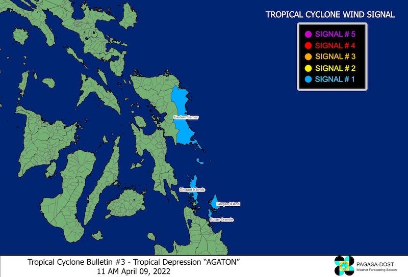
DAVAO CITY (MindaNews / 09 April) — Typhoon signal number 1 has been raised over Dinagat, Siargao and Bucas Grande islands in Mindanao and Eastern Samar in Visayas due to tropical depression ‘Agaton,’ the state weather bureau’s Tropical Cyclone Bulletin 4 issued at 2 p.m. on Saturday said.
Dinagat, Siargao and Bucas Grande islands were badly hit by super typhoon ‘Odette’ in December last year.
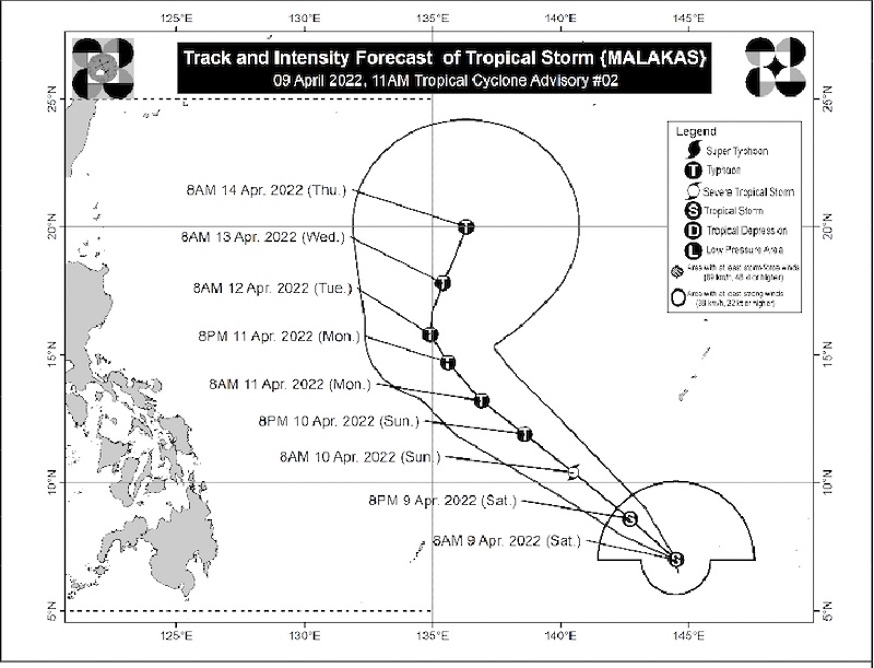
Tropical Storm ‘Malakas’ on the other hand was spotted at 1,965 kilometers east of Mindanao as of 10 a.m. on Saturday, according to the Tropical Cyclone Advisory 2 issued at 11 a.m.
‘Agaton,’ PAGASA said, will bring moderate to heavy with at times intense rains over Eastern Visayas, Dinagat Islands, and Surigao del Norte from Saturday until Sunday morning while light to moderate with at times heavy rains will be experienced in Masbate, Sorsogon, and the rest of Visayas and Mindanao.
 SIgnal 1 over Dinagat, Siargao and Bucas Grande islands in Mindanao and Eastern Samar in the Visayas as of 11 a.m. on Saturday, 08 April 2022 due to tropical depression ‘Agaton.’ Courtesy of PAGASA
From Sunday morning to early Monday morning, PAGASA said there will be moderate to heavy with at times intense rains over Eastern Visayas, Dinagat Islands, Surigao del Norte, the northern and central portions of Cebu including Bantayan and Camotes Islands, and Bohol. Light to moderate with at times heavy rains over Masbate, Sorsogon, and the rest of Visayas and Mindanao.
PAGASA warned of “scattered to widespread flooding (including flooding) and rain-induced landslides” in areas that are highly or very highly susceptible to these hazard as identified in hazard maps.
 Track and intensity forecast of tropical storm ‘Malakas’ as of 11 a.m. advisory, 09 April 2022. Courtesy of PAGASA
PAGASA’s Tropical Cyclone Advisory 2 on tropical storm ‘Malakas’ as of 11 a.m. Saturday said, it has maximum sustained winds of 75 kph near the center, gustiness of up to 90 kph and central pressure of 996 hPa (hectoPascals) and was spotted north northwestward at 10 kph.
‘Malakas’ is expected to bring in strong winds of “up to 340 km from the center.”
According to PAGASA’s track and intensity forecast, ‘Malakas’ will be 1,800 km east of Mindanao by 8 pm Saturday and 1,645 km east of Mindanao as of 8 a.m. on Sunday, both outside the Philippine Area of Responsibility (PAR).
The advisory said ‘Malakas’ may enter the PAR by late Monday or early Tuesday then turn to the northeast or north northeast by Wednesday.
It also said ‘Malakas’ is forecast to “continue intensifying throughout the forecast period, reaching typhoon category by late Sunday or early Monday” and a peak intensity of 155 kph may be reached on late Monday or early Tuesday.
The advisory also noted that ‘Malakas’ is “unlikely to directly affect the weather condition in the country” but may influence the movement and development of Tropical Depression ‘Agaton’ as it tracks generally northwestward towards the PAR region. (MindaNews)
