KUSIONG, Datu Odin Sinsuat, Maguindanao (MindaNews / 19 August) — As the siren sounded at 7 a.m. on Saturday, August 17, exactly 43 years after the 1976 tsunami that left at least 8,000 dead and missing along the Moro Gulf, residents applied what they learned from previous disaster drills: duck, hold and cover.
When the shaking stopped, hundreds of villagers flocked towards the campus grounds of Bai Hanina Sinsuat High School, designated as evacuation site by the Bangsamoro government’s Rapid Emergency Action on Disaster Incidents (Bangsamoro READi) for the multi-hazard simulation drill.
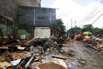
 Residents of Kusiong in Datu Odin Sinsuat, Maguindanao participate in the multi-hazard simulation drill initiated by the Bangsamoro Autonomous Region in Muslim Mindanao on Saturday, August 17, 2019, exactly 43 years to the day a magnitude 8.2 earthquake triggered a tsunami along the Moro Gulf and left at least 8,000 dead and missing. Maguindanao postied the highest death toll in 1976 with Kusiong among the areas badly hit. MindaNews photo by FERDINAND B. CABRERA
A helicopter hovered, assessing the situation on the ground. Speedboats of the Philippine Navy, Coast Guard and different rescue teams rushed to a respond to a drowning scenario from a capsized boat.
Minutes later, ambulances, rescuers and hospital staff arrived to rescue an estimated 50 persons representing those who were wounded in the aftermath of the magnitude 8.1 earthquake that triggered a tsunami.
Forty-three years ago, a magnitude 8.2 earthquake triggered what has been referred to as the country’s “most disastrous tsunami.”
BARMM Local Governments Minister Naguib Sinarimbo, who also heads the Bangsamoro READi, said the exercise was meant to look at the integration of responses from local government units to barangays. “It’s a vertical and horizontal integration,” he said.
Sinarimbo said they hope to link up government offices or ministry, security sector, private sector and the communities, to include communities of the Moro Islamic Liberation Front (MILF), and bring in institutions which were not part of government before.
Assessment
Engr. Rainier Amilbahar, head of the Philippine Institute of Volcanology and Seismology (Phivolcs) in Cotabato City and the BARMM noted that an indigenous warning device of the Tedurays which was showcased during the first tsunami simulation in 2014 was not used in Saturday’s drill.
He said hitting a piece of bamboo hanging in a strategic location in a Teduray’s house serves as an early warning device and the other areas have in fact followed this practice following the 2014 drill.
He said the bamboo has been an effective warning device long before sirens and whistles became popular.
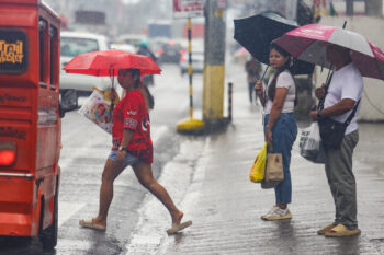
Representatives of the Mindanao Humanitarian Team (MHT), a group of humanitarian agencies, observed that not everyone participated in the drill and cited an instance when a fish vendor was still doing business in the midst of the drill.
They also pointed to poor communication signal, suggesting the need for a stronger UHF and VHF signal or satellite phone for responders.
Some of the participants apparently forgot they were in a drill as they ended up looking at the helicopters hovering instead of portraying their roles.
The tagging of supposed casualties also posed some problems.
 Residents pretending to be dead during the multi-hazared simulation drill on Saturday in the coastal town of Kusiong in Datu Odin Sinsuat, Maguindanao, one of the hardest hit during the magnitude 8.2 earthquake that triggered a tsunami on August 17, 1976. MindaNews photo by FERDINANDH B. CABRERA
But there were good practices that were also observed. Participants who acted as residents fleeing to higher ground did not forget to bring their “go bags” which contained food, personal hygiene and emergency kit, diaper, napkin, water, personal documents like birth certificate and passports.
Observers lauded the spacious evacuation site where areas for the evacuees and those needing treatment were delineated, and the immediate conduct of psycho-social activities for the children.
Responders who had no stretchers but made improvised ones to carry their patients to the treatment area were praised for their ingenuity.
1976 tsunami survivors
Ricardo Fering, 81 and his wife, Lourdes, 80 can still recall vividly what happened when a magnitude 8.2 earthquake struck shortly after midnight on August 17, 1976, and the tsunami that followed.
The couple at that time lived in Minandar, an uphill village fronting the Kusiong village and the seashore.
“Our hut was like a hammock in full swing,” Ricardo recalled.
 Ricardo Fering, 81 and his wife, Lourdes, 80 of Kusiong in Dato Odin Sinsuat, Maguindanao, can still vividly recall when a magnitude 8.2 earthquake struck shortly after midnight on August 17, 1976, triggering a tsunami.
MindaNews photo by FERDINANDH B. CABRERA
By daylight, he attempted to go to Cotabato. As he walked, he saw dead fish scattered on the ground along with dead persons.
Lilia Suban, 67, a resident also of Mindanar, said shortly after they were jolted by the quake, they heard “a loud rumbling of rocks… it was like war, rocks falling from the hill” before the huge waves swallowed everything on its path.
It took three days for the news to reach the other villages. At that time, the word ‘tsunami’ was still unheard of in these parts. It was merely referred to as “tidal wave.”
Ricardo recalled that government response also took days as responders had to clear the roads of debris from the tsunami and landslides. At that time, too, there were no telephones in the area and other means of communications were cut off.
Amilbahar said the Celebes fault has been consistently active since 1600.
“That is why we have to be always ready,” he said.
8,000 dead
About 8,000 were reported dead or missing, some 10,000 injured and an estimated 90,000 were rendered homeless, according to a 1978 report prepared for the Special Committee on Tsunami Warning System of the National Committee on Marine Sciences of the National Science and Development Board.
The tsunami affected 700 kilometers of coastline bordering the Moro Gulf, affecting the coastal areas of Maguindanao, Sultan Kudarat, Lanao del Sur, Lanao del Norte, Zamboanga del Sur, Basilan, Sulu and the cities of Cotabato, Zamboanga and Pagadian. Maguindanao posted the highest number of dead and missing, followed by Lanao del Sur.
Ninety five per cent of the casualties were due to the tsunami, the report said.
The waves ranged from 4.3 meters (14 feet) to nine meters (29 feet).
Waves were reported to be higher than five meters in Linek and in Kalanganan in Cotabato City, Pagadian City, Sacol Island in Zamboanga City. In Lebal, Sultan Kudarat, “waves may have been as high as nine meters,” the report added. (Ferdinandh B. Cabrera / MindaNews)