DAVAO CITY (MindaNews / 30 Jan) – The Regional Development Council (RDC) 11 discussed Tuesday whether or not to relocate the entire municipality of New Bataan in Compostela Valley (ComVal) considering the devastation brought by typhoon Pablo.
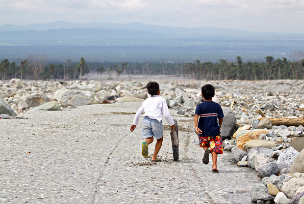
 BOYS WILL BE BOYS. Boys find time to play on 28 Jan 2013 amid the destruction caused by Typhoon Pablo in Barangay Andap, New Bataan, Compostela Valley. MindaNews photo by Erwin Mascarinas
In an interview, Ed Arreza, regional director of the Mines and Geosciences Bureau 11, said there is no final decision yet on whether to relocate New Bataan to new areas or maintain its location but engineering interventions will be applied.
The interventions, he said, may include preventing the river to overflow and creating concrete canals to redirect the flow of water.
The Mayo River created a new course toward the center of Barangay Andap in New Bataan, wiping it out, including the barangay hall, and replacing it with rocks and boulders.
Arreza said it is possible to control the flow of water, citing the case of Jakarta in Indonesia that used to be flooded about five years ago.
He said because of engineering interventions, Jakarta is no longer being flooded now.
It is possible to do it in New Bataan, he said, adding, “If we have the money to move 20 million cubic meters of rocks and debris.”
He noted that the economic aspect should be mostly considered, adding that the planning, design and cost of possible engineering interventions will follow after the body’s final decision.
Arreza admitted though that Pablo’s immensity was unprecedented.
He pointed out that flood has occurred since the time of Noah (Biblical story), citing that Davao del Norte and Monkayo in ComVal are already flood-prone areas even in the past.
Further, Arreza said the MGB will not allow rebuilding the old Andap area, considering its high susceptibility to flood.
But he said the municipality of New Bataan can still be reconstructed as long as its municipal hall and schools, among other existing infrastructures, can be protected.
“If the whole New Bataan was totally wiped out, there is no more justification to reconstruct it unless in safer areas,” he added.
Relocation sites
The MGB-11 identified proposed relocation sites in Compostela, Montevista, Monkayo, Laak and New Bataan of ComVal.
For New Bataan, Arreza said in his report to the RDC-11 the sites are Purok 15 in Barangay Panag and Sitio Pagsilaan in Barangay Andap.
In Compostela, the relocation sites are Habitat for Humanity (National Housing Authority), Purok 3 in Brgy. Osmeña, Canceran Property, Purok 2 and Pascual Property, Purok 2 in Brgy. Maparat.
There are nine proposed relocation sites in Monkayo.
These are Purok 4, Sitio Crossing Jaguimitan in Brgy. Jaguimitan, Purok 3 in Brgy. Rizal, Purok 3, Sitio Maite in Brgy. Poblacion, Purok 3, Sitio Bosquit in Brgy. San Jose, Purok 2 in Brgy. Upper Ulip, Purok 7 – Bliss in Brgy. Baylo, and Pasian National High School and Purok 3, Lamdag in Brgy. Pasian , and Proper in Brgy. Salvacion.
In Laak, the relocation sites are Simagala and Jordan Properties, Purok 1, and Barangay Site in Brgy. Kidawa.
In Montevista, the relocation sites are Purok 2 in Brgy. Canidkid, Brgy. Tapia, and Purok 8 in Brgy. New Visayas.
Arreza said that geohazard maps with scale of 1:10,000 for Maco, Monkayo and Pantukan are already available, while that of New Bataan is still in the process of digitization as it was only done in January this year.
These maps, he said, are helpful in identifying relocation sites to avoid disasters in the future.
Arreza said out of 49 cities and municipalities in the region, 26 of them already have the 1:10,000 geohazard maps, while the rest will be completed by 2014.
Available geohazard maps are of San Isidro and Talaingod in Davao del Norte, and Bansalan, Don Marcelino, Magsaysay, Malalag, Matanao, Santa Maria, and Sulop in Davao del Sur.
In Davao Oriental, the geohazard maps of Cateel, Manay, and Mati are available, while that of Baganga had only been completed this month and its digitization is ongoing.
In Davao City, only the geohazard map of Marilog District is available.
Except for Island Garden City of Samal and Sarangani, geohazard maps in 1:50,000 scale of all cities and municipalities are available at the MGB-11 office.
Arreza said the geohazard maps in 1:10,000 scale are more detailed than the ones in 1:50,000 scale. He cited that the observation in 1:10,000 scale maps is by 100 to 500 meters, while the map in 1:50,000 scale is only by a kilometer.
He cited that municipalities that used to be entirely in color red or high susceptibility to landslide in geohazard maps with a scale of 1:50,000 have portions with green or moderate susceptibility and yellow or low susceptibility to landslide in maps with 1:10,000 scale. He added that areas that are not in red can still be used as relocation sites. (Lorie Ann A. Cascaro / MindaNews)
