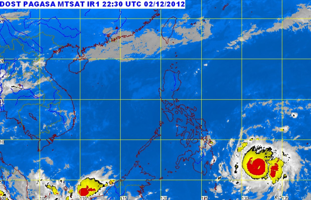
SURIGAO CITY (MindaNews/03 December) — Storm signal number 2 has been hoisted over Surigao del Sur and the northern part of Davao Oriental which is expected to experience stormy weather with rough to very rough seas as typhoon Pablo (international codename ‘Bopha’) is fast approaching landfall.
 At 10:00 a.m. today, 03 December 2012, Typhoon “PABLO” was located based on satellite and surface data at 550 Southeast of Hinatuan, Surigao del Sur (6.9°N, 131.4°E).
The Philippine Atmospheric Geophysical and Astronomical Services Administration (PAGASA) in its 5 a.m. weather forecast said the two provinces will experience “rough to very rough seas” while northern Mindanao, the rest of Caraga region, Davao del Norte, the rest of Davao Oriental, Compostela Valley, Eastern Visayas, Bohol, Camotes Island and Siquijor will have “rains with gusty winds with moderate to rough seas.”
Thirteen of 26 Mindanao provinces have been placed under storm signal number 1: Surigao del Norte, including Siargao Island; Dinagat Islands province, Agusan del Norte, Agusan del Sur, the rest of Davao Oriental, Davao del Norte including the Island Garden City of Samal, Compostela Valley, Bukidnon, Misamis Occidental, Misamis Oriental, Camiguin, Lanao del Norte and Lanao del Sur.
Pablo is expected to make landfall on Tuesday. PAGASA forecast says Pablo will be 175 km East of Hinatuan, Surigao del Sur by Tuesday morning.
As of 6 a.m., Monday, Pablo was spotted based on satellite and surface data at 645 kilometers southeast of Hinatuan in Surigao del Sur. At 5 a.m. it was located 670 kilometers.
At 4 a.m., PAGASA’s advisory said the eye of typhoon Pablo was at 700 kilometers southeast of Hinatuan with maximum sustained winds of 175 kph and gustiness of up to 210 kph and was expected to move west northwest at 24 kilometers per hour.
In Surigao City, the Surigao del Norte Electric Cooperative announced at the City Disaster Risk Reduction and Management Council meeting Monday morning that they would cut trees that may threaten houses and buildings when the super typhoon,expected to be stronger than the 1984 typhoon Nitang, makes landfall.
As of 8 a.m., skies were overcast here and in the Cancarmadcarlan (Cantilan Carrascal, Madrid, Carmen, Lanuza) towns of Surigao del Sur.
In Cantilan, Surigao del Sur, Chito Trillanes of the Social Action Center told MindaNews, as that as of 7:05 a.m. “makulimlin na pero di pa malakas ang ulan” (skies are overcast but no heavy rains).
As of 8:05 a.m. in Baganga, Davao Oriental, Lt. Col. Krishnamurti Mortela, chief of the 67th Infantry Battalion, told MindaNews “it’s still sunny here but partly cloudy skies and occasional rainshowers. No gusty winds so far.”
Unlike last year’s Sendong, where at least 1,200 persons were killed in Cagayan de Oro and Iligan cities and some parts of Bukidnon, local government units have been busy since the announcement of the coming of a super typhoon, to prepare for Pablo’s arrival.
In Compostela Valley, Governor Arturo Uy told MindaNews they will do preemptive evacuation in landslide-prone and flood-prone areas. Raul Villocino, head of the Provincial Disaster Risk Reduction and Management Council (PDRRMC) said they are making preparations for the preemptive evacuation in the landslide and flood-prone areas in the towns of Compostela, New Bataan, Montevista and Monkayo, including the gold-rich Diwalwal. He said announcements would be made at noon.
In Cagayan de Oro City, preparations had been made as early as Saturday to evacuate at least 15,000 families living in critical areas along the Cagayan de Oro River ahead of typhoon Pablo.
Engr. Armen Cuenca, assistant disaster officer, said last Saturday that the evacuation may start on Sunday night or early Monday.
Even Davao City, which is not in the eye of the storm as it is in the southern part of Mindanao and the path of the storm is in the northeastern part, barangays and the city government are on alert. (Vanessa Almeda and Carolyn O. Arguillas/MindaNews)
