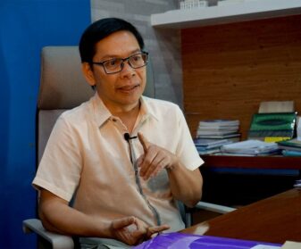
DAVAO CITY (MindaNews/12 January) – Ruby and I were supposed to finish editing the photos we took on the aftermath of Tropical Storm Sendong Cagayan de Oro City and Iligan cities when I heard on radio that another tragedy occurred in Pantukan, Compostela Valley, a gold rush site. I haven’t unloaded some of the things in my backpack after the trip to the disaster-stricken cities, nor drained the water in my bladder pack. The headlamp and some camera accessories were still inside the bag too.
The first report said six persons were already confirmed dead while some were reported missing. A few minutes later, the military reported that 16 bodies had been pulled out from the mud and rubble.
I asked Carol if we could go with Gigi. She said, go ahead.
Although I had no idea where exactly the landslide site is, I knew it would be a long uphill ride because I heard about the gold rush sites, sitios Diat 1 and Diat 2, last year when we covered the landslide in Sitio Panganason in neighboring barangay Kingking. Sitios Diat 1 and 2 are in Napnapan.
While preparing to leave, I scanned my phone directory if I still had the number of a certain Alex, an employee at the office of the mayor. Luckily, I still have it. So I called him to ask how far the landslide site is. He told me that it’s just on the other side of Sitio Panganason. He said we could go there either via Barangay Tibagon which would take at least two hours by motorcycle, or via Sitio Panganason, which would take more than an hour but we have to walk for about 30 minutes.
I sent a text message to Maj. Jake Obligado, commander of the 10th Civil Military Operations (CMO) Battalion, asking him if we could ride the chopper together with the rescue workers even if I knew it would be hard to find a landing zone given the site’s rugged terrain. He didn’t reply. But I understand he has other priority concerns, particularly coordinating the rescue efforts with their counterparts on the ground.
Also, in times of disaster, while we know that journalists would compete who can file the first report, we must understand that choppers are meant to transport the survivors from the site to the town proper for medical treatment.
On our way to Pantukan with Toto Lozano, we could see the clouds already kissing the Diwata Mountain Range. It presaged bad weather. So we assumed that it would really be difficult for the chopper to find a landing zone. As we entered the town proper, we saw the aircraft hovering over the town proper on its way to Kingking Elementary School, the landing zone during the rescue operation last year.
We went straight to the incident command post in front of the Pantukan town hall. Journalists, both from print and broadcast, were already there waiting for the briefing. After the briefing, we learned that there was no landing zone and the retrieved bodies had to be brought down to the town proper on a dump truck. Last year, the retrieved bodies were transported using motorcycles.

Experienced drivers
Ruby and I decided to hire a motorcycle, locally known as habal-habal. We knew that it would be a rough ride; we had to get the best driver.
Toto took charge of covering the survivors at the hospitals and the families of the victims. He would wait, too, for a chance to ride the chopper for an aerial survey if the weather permitted.
Again, I called up Alex and asked him if he could help us find the best driver available for our own safety even if hundreds of motorcycles are plying the route. It does not mean that we don’t trust the local villagers; it’s all about getting safe to our destination without any scratches and broken bones.
Alex sent Bibo, a 34-year old driver who has been plying the route for 14 years. I asked Bibo which is the shortest route. He said the route via Barangay Tibagon is more convenient because we don’t have to hike to the landslide site. But since it’s already 1p.m. and the weather was getting bad, we were forced to take the route via Sitio Panganason and hike. But he told us it’s going to be short, like 30 minutes. We dropped the Tibagon route because it might rain and the rivers will be flooded, and we couldn’t make it back.
We had our rain boots on and had raincoats inside our bags. Almost halfway to Sitio Panganason, a heavy rain poured. We had to put our raincoats on, and of course, wrap the cameras with plastic. After an hour and 15 minutes, we were already in Panganason, 15 minutes ahead of the usual travel time. From there, we had to pass by shanties and narrow alleys in going to Sitio Haguimit, where we would descend to Sitio Diat 2, at the foot of the landslide site. Only motorcycles can pass the road to Haguimit.

It was raining pretty hard when we arrived in Haguimit. The villagers told us that we should not descend from Diat Uno, where the landslide originated because it was too dangerous. Besides, we had to hike for 20 minutes then descend through the boulders and mud. We did not take the risk but instead descended through the route known as Nangkaan, named after the jackfruit trees that grew near the trail made more slippery by the rain. We had to use both of our hands to hold on to twigs, roots and rocks.
On our way down, we could still hear the machines used in ball mill plants. Everything seemed normal, as if nothing happened down in Diat Dos.
After 10 minutes of steep descent, we’re still halfway to our destination. Bibo pointed to us the location of the landslide, which we couldn’t see from our position. We could only see the villagers standing on a cliff, which turned out later to be the edge of the hill that collapsed. Ten minutes more and we finally arrived in Diat Dos, happy to survive the 200-meter descent.
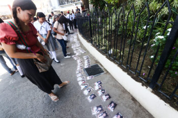
The trail ended on the dirt road that leads to the national highway in Barangay Tibagon. Just across the end of the trail was an unfinished shanty. Built using lumbers and galvanized iron sheets, it served as a “temporary morgue,” and stood right outside the Hexat Mining Corporation compound.
The stench of four corpses in body bags greeted us. We took a few shots of the body bags. Five minutes later, rescue workers carrying another body bag walked towards the gate of the compound.
After taking some more shots, we walked towards the people we saw on our way down.
To my right, I was stunned by the massive mud and debris that swathed the gold rush site. A house was leaning on its side, the posts were wrecked but the roof was still intact. We were told that the family who owns the house was able to survive, though slightly hurt.
As I looked down, I could see debris and felled trees that were draped with mud. Several people were also digging through the dirt and rubble.
While we were warned to be cautious because there was still movement of the soil in the upper portion of the mountain, we could still see some people coming down through the path of the landslide.
Ruby and I checked on around 10 persons digging through the mud using water and hand tools. The ground was still soft. I was thinking if it was really safe to stand beside those who were digging. After taking a few shots, I asked Ruby to descend again.
At least 30 meters below, at least 20 persons were also digging. They said they recovered the five bodies near the bottom of the landslide.
All the rescue volunteers turned out to be workers of the mining company and small-scale miners in the area.
Earlier that day, we heard on the radio reports that the military and police dispatched one platoon each to assist in the rescue operations. But we were surprised that only the local villagers were actually doing the rescue efforts.
Yes, we saw the police and Army. They were actually around, probably securing the site.
Gunshots warning
While we were taking pictures at the bottom of the landslide, gunshots rang at 3:50pm from the top of the mountain. Then the people on the higher portion of the mountain shouted to us to climb back to the safer grounds.
It took us about 10 minutes to descend from the compound, but in just a few seconds, we were able to ascend halfway. All of those in the path of the landslide also rushed to the safer grounds. No one was left.
Ten minutes after the first gunshots, at least three more rang from the top of the mountain. Everyone left the path of the landslide. This time, the rescue volunteers decided to call off the rescue efforts because it might rain again.
I learned from the villagers that they were actually warned hours before the landslide.
At around 12 midnight, after interviewing some villagers and miners, I saw three women sitting outside a shanty. One was still crying, while the two others looked very worried. I was hesitant to interview them because I understood they needed some space. One guy told me that the one who was still crying is the wife of one of the missing miners. The two others are her sisters, whose husbands were also miners but were able to survive.
We headed back to Haguimit, another grueling 200-meter ascent. Back home, it was just sad to imagine how the lives of these poor people would end. They had no choice; they had to risk their lives to feed their families. For most of them, dying and surviving the landslides have become a part of their lives in the rugged mountain range of Mt. Diwata. (Keith Bacongco/Mindanews)