SAN FRANCISCO, Agusan del Sur (MindaNews / 20 December) — Concerned residents here expressed alarm that the massive flooding at the town center brought about by Tropical Depression ‘Vicky’ on Friday could have been triggered by the clearing of a four-hectare sloping land for housing development inside the one-kilometer buffer zone of Mt. Magdiwata Watershed.
At least 1,658 hectares of the watershed, which is the only source of potable water of this highly developing town, is a fully delineated protected area under Presidential Proclamation 282 in 1994 issued by President Fidel Ramos.
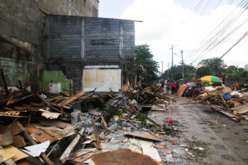
 Residents in San Francisco, Agusan Del Sur expressed fear that that a housing project on the slope inside the buffer zone of the Mt. Magdiwata watershed triggered the massive flooding Friday, December 18, 2020 as Tropical Depression ‘Vicky’ slammed across northeastern Mindanao. MIndaNews photo by CHRIS V. PANGANIBAN
John Columban Paredes, son of former Agusan del Sur governor and congressman Ceferino Paredes Jr., presented through his social media page, his own study using a geological map of this town and how a huge bulk of floodwaters cascading through the path of the sloping area that had been cleared by a bulldozer, submerged the outlying communities situated at the foot of mountain as early as noon on that fateful day.
Paredes, who ran for mayor and lost by a small margin in last year’s polls, said this is the first time in many years that the barangays of San Isidro and Karaos, situated along the Davao-bound national highway were first hit by flashfloods when what is usually submerged during continuous heavy rains in the past were Barangays 1 and 3, caused by a run off from a nearby overflowing Gibong River.
Julito Cerna Pacna, 57, a long-time Manobo resident and a barangay tanod of San Isidro, recalled a warning from their elders in the tribe who had passed away, not to disturb the sloping land planted with trees and coconuts since it would cause a destructive landslide that would affect hundreds of homes below.
“In the distant past, the bulk of water coming from Mt. Magdiwata watershed during rains that lasted for weeks would just slowly cascade following the natural waterways and creeks,” Pacna said, adding that the wide area of the buffer zone belongs to the ancestral lands of the Maguinda and Bando Manobo clans, the original settlers of the area.
But during the road tracing works in the sloping area with the use of bulldozer by the Bayugan City-based developer Marrea Estates on November 30, the waterways, creeks and natural springs were dumped with soil to flatten the deep portions.
Covered creek
Friday’s heavy rains brought by ‘Vicky’ cleared the dumped portions as the huge bulk of water coming from the forested area above naturally spurt out and restored the paths of its waterways.
Bonifacia Arevado, a radio host and owner of a local FM radio station whose house is just below the protested four-hectare housing development project, posted video clips in her social media post showing the rampaging floodwaters from above the mountain, threatening a mudslide towards the houses below.
Engr. Mardie Para, project engineer of the Maria Estates housing development, explained there were no creeks when they first visited the area. What they saw, he said were deep portions where the water flows that were bulldozed by the former developer who sold the area to their company.
“We have no intention to destroy the environment and the lives of people living below. We enter the area in good faith,” Para said.
But Arevado insisted there was a creek with pure clear water inside the area where they used to wash their clothes and took a bath.
No clearance?
Elmer Luzon, general manager of the San Francisco Water District (SFWD), agreed with Arevado. He said SFWD had water spring sources they tapped from the watershed.
On Friday and Saturday, residents in the five barangays of the poblacion and nearby villages suffer watered shortage after pipelines from the spring sources of Mt. Magdiwata watershed were destroyed by the rampaging floodwaters.
Most of the town council members opposed the housing development project after they learned from media reports about the earth moving activities by the developer last month without clearance and coordination with them.
Councilor Genden Dayondon, chair of the Committee of Ecology, Natural Resources and Environmental Protection, vowed to block the continuation of the housing project. “We will not allow this happen ,” he said in an interview.
Councilor Jay-Ar bde Asis, in his social media post, wrote: “I strongly oppose and object by all means on the application of Marrea Estate housing project.”
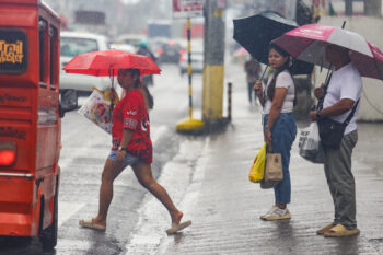
 The rotunda of San Francisco, Agusan del Sur had never experienced flooding until Friday, December 18, 2020 Photo by RICHARD GRANDE
Marrea Estates, however, was able to get a zoning certification on November 25 from the Office of Zoning Administrator as part of the residential zone based on the approved land use and zoning plan approved by Municipal Ordinance No. 007 in 2015.
The developer also managed to get an endorsement on the application of subdivision plan from the barangay council of Karaos.
An ordinance in 2014 authored by former town councilor Lerriza de Leon prohibited any earth moving activities within the one-kilometer buffer zone of Mt. Magdiwata Watershed.
Forester Adolfo Ariño, municipal environment and natural resources officer, said Marrea Estates reneged on their agreement on status quo on any earth moving activities while the company is still processing required government documents for the housing project.
Forester Jerome Albia, community environment and natural resources officer of the Department of Environment and Natural Resources based in Bunawan town, said the company could be violating environmental laws since they started to develop the area without environmental clearance certificate (ECC) and the only ECC they are holding is for land conversion from agricultural to residential in 1996.
Albia said they will conduct further study in the area with an overlay survey and with the help of Mines and Geosciences Bureau, check if the area falls within the geohazard map of the Philippine fault line. (Chris V. Panganiban / MindaNews)