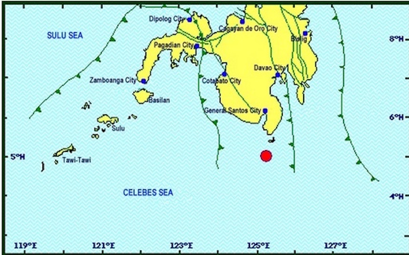
DAVAO CITY (MindaNews/ 29 April) — A magnitude 7.2 earthquake roused residents from sleep in the southern part of Mindanao at 4:23 a.m. Saturday, its epicenter recorded at 53 km southwest of Sarangani in Davao Occidental, the Philippine Institute of Volcanology and Seismology (Phivolcs) said.
In its Earthquake Bulletin 2 issued at 5:06 a.m. Phivolc said the quake was felt at Intensity V in the cities of General Santos and Koronadal; Santa Maria, Jose Abad Santos, Don Marcelino, Balot Island in Davao Occidental; Polomolok and Tupi in South Cotabato; Alabel, Malapatan and Glan in Sarangani; and Palembang in Sultan Kudarat.
 Courtesy of Phivolcs
The quake registered Intensity IV in the cities of Davao, Cotabato and Zamboanga, Intensity III in Cagayan de Oro City and Intensity II in Kidapawan City.
A magnitude 4.1 aftershock was recorded at 4:54 a.m. with epicenter at 64 km SW of Sarangani, Davao Occidental; magnitude 3.1 at 6:39 .a.m. at 57 km NW of Sarangani; and 2.8 at 6:50 a.m.
Social media posts from residents described how they were roused from sleep and rushed out of their houses.
Fr. Joel Tabora, President of the Ateneo de Davao University, wrote on his Facebook account that the Jesuits, who reside on the 10th floor, “evacuated our building and met one another in the streets.”
“There, in a show of courage as we coped with our rattled nerves, we sang Happy Birthday to Fr. Tony Basilio and declared his natal day earthshaking,” Tabora wrote.
Power was cut cut off in General Santos City but was immediately restored.
Also in General Santos, vendors were seen sifting through the rubble of an old, abandoned building that collapsed during the quake. The building had earlier been set for demolition.
Phivolcs issued Tsunami Bulletin 1 at 5:03 a.m. to warn residents in the coastal areas where the quake was felt to watch out for sea level disturbances such as strong currents and rapid rise and fall of seawaters
“Based on tsunami wave models and early tide gauge records of the tsunami in the Philippine Sea, coastal areas in Philippine provinces fronting the Celebes Sea are expected to experience wave heights of less than one meter above the normal tide levels,” it said.
It said the first tsunami waves were to be expected to arrive “between 4:28 a.m and 5: 23 a.m.”
Residents in Sarangani, Davao Occidental. South Cotabato, Davao Oriental and Sultan Kudarat were advised to “stay away from the beach and not to go to the coast fronting the Celebes Sea… until the threat has passed.”
Phivolcs said the threat has passed.
Maggie Diaz, a resident of General Santos City, said the strong quake was “super hadlok” (super scary). “Apart from the movement, narinig ko iyong (I heard the) sound that reminded me of the 1976 earthquake,” recalled Diaz who resided in Cotabato City then. “Dinaan kami sa bintana para malabas sa bahay” (We had to pass through the window to get out of the house), she said.
The August 17, 1976 quake was recorded at magnitude 8.2, triggering the country’s “most disastrous tsunami,” affecting 700 kilometers of coastline bordering the Moro Gulf. The quake and tsunami left 8,000 dead or missing, about 10,000 injured and about 90,000 homeless, according to a 1978 report for the Special Committee on Tsunami Warning System, the National Committee on Marine Sciences and National Science Development Board.
Powerful quakes that struck Mindanao this year include the magnitude 6.7 quake that struck Surigao late evening of February 11 and the magnitude 6 earthquake that roused residents from sleep in Wao, Lanao del Sur and Kalilangan, Bukidnon.
The Surigao quake left eight persons dead, scores injured and damaged several buildings, road portions and bridges. Like the quake-struck areas in Suirgao, Wao and Kalilangan towns were also placed under a state of calamity. (Carolyn O. Arguillas / MindaNews)
