DAVAO CITY (MindaNews/11 August) — Universities and colleges in Mindanao have been tapped for the Philippine Light Intensity Detection and Ranging (Phil-LIDAR) project, which aims to map the river systems of four regions in the island.
The Phil-LIDAR project is an offshoot of the Department of Science and Technology’s Disaster Risk and Exposure Assessment for Mitigation (DREAM) project, which aims to scan the country’s river basins to produce 3D maps of flood hazard zones, according to the DOST website.
The University of the Philippines Mindanao has been tasked to work alongside the agency for Region 11. Ateneo de Zamboanga University, Central Mindanao University, Mindanao State University – Iligan Institute of Technology and Caraga State University will work for Regions 9, 10, and 13, respectively.
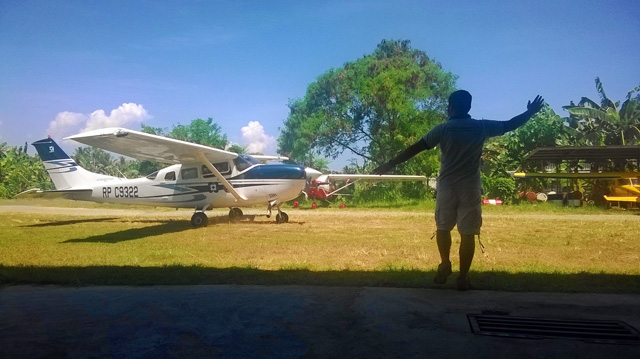
In an interview Saturday afternoon, Pearl Mars, Phil-LIDAR senior science specialist, said their technicians are now mapping Davao Region’s river systems using a Cessa plane rigged with Lidar equipment.
The mapping would cover the Talomo, Lipadas, Tagulaya-Sibulan, Digos and Padada-Mainit river systems for Davao del Sur; Lasang for Davao del Norte; Matibo for Compostela Valley; and Baganga-Mahanep, Manurigao, Caraga, Casauman, Quinonoan, Bugnan-Mayo, Bitanayan, and Sumlog river systems for Davao Oriental.
Mars said typhoons Pablo and Sendong inspired the project, which would allow local governments to access scientifically collected data to help them in planning mitigation measures for disasters.
“The data that would be collected take around three months to validate and model,” she said, adding local government units can write the DREAM project headquarters in Metro Manila to request copies of the data.
She said the DOST regularly turns over the data to local government units.
The equipment, she added, costs at least P100 million each, with three planes on lease circling the country to monitor a total of 18 major river basins.
 A ground crew member guides a DOST-UP LIDAR Project aircraft at the old Davao City airport in Sasa. A team from UP is taking turns manning the DOST equipment aboard the Cessna plane to map the Davao region’s river systems and flood plains.
The project runs for three years, from May 1 this year to April 30, 2016.
The Phil-LIDAR team has been in the region starting last month and has been sending gigabytes of data every day to the headquarters since their arrival.
Among the areas that would be flown over were the Tagum, Cagayan de Oro, Iligan, and Butuan flood plains, Mars said.
According to the project design, the higher educational institutions such as UP Mindanao are part of the ground team that would validate the data collected from both ground and airborne equipment.
The data would be filtered to extract the digital terrain model from the digital surface model.
Features significant to flood modeling and flood impact assessment such as buildings, forest cover, and road and river network will also be extracted, the document said.
The ongoing DOST-GIA Nationwide DREAM Program covers only 1/3 of 100,000 sq km of 18 major river basins in the Philippines.
The proposed program aims to cover the remaining 2/3 of river systems in the country by tapping the state and private colleges and universities nationwide in processing and validating its components.
Mars said the team has proposed acquiring a fourth aircraft and LIDAR equipment. “Hopefully, by next year, we would already have four aircraft flying.”
The first two aircraft were acquired in November and December 2012, with the newest being acquired by the team in January 2014.
Aside from disaster mitigation, local government units can access data on coastal resources and forestry, even agriculture and renewable energy, using the information collected throughout the project duration.
The DREAM project is a component of Project NOAH (Nationwide Operational Assessment of Hazards), which also tabulates the flood-prone areas in the Philippines. (MindaNews)
