ILIGAN CITY (MindaNews / 30 April) – When I posted on social media a photo of my family standing in front of our diminutive Wigo taken somewhere deep in the forest of Rogongon along the Iligan- Bukidnon road on Easter Sunday, I didn’t expect it to generate so much reaction from friends.
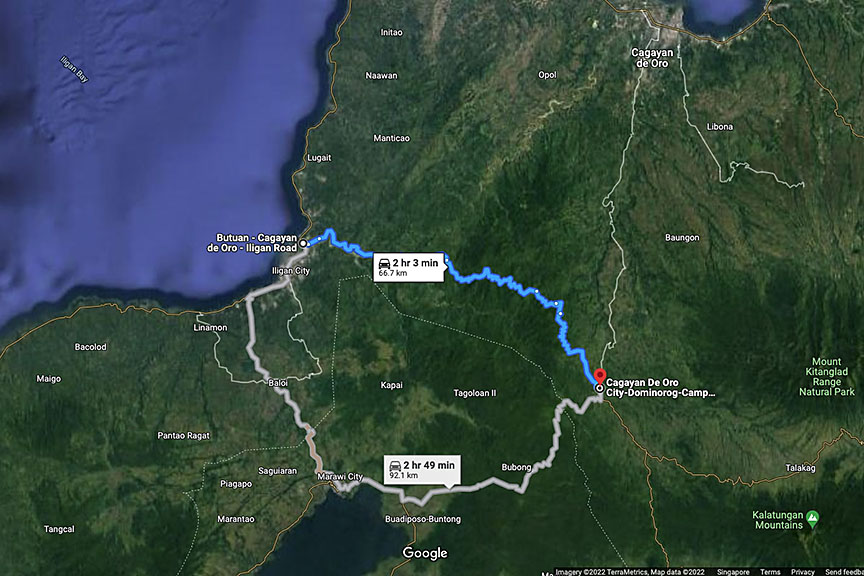 The Iligan-Bukidnon Road via the highlands of Rogongon. Map courtesy of Google
Everybody wanted to know if we reached Talakag in Bukidnon, if we arrived home safely, if the roads are okay.
We got home all right. Although I did have concerns over safety before we took the plunge, it was an uneventful ride really, just like driving any highway. I have to admit that there was a brief moment when my mind went into panic mode, but I kept my cool and my wife noticed nothing.
Looking back, yeah, I would understand why people were so concerned, thank you very much.
I have oh so wanted to pass through this road, a highway conceived by the late Congressman Mariano Badelles Sr. way back in the 1980s.
Rogongon is Iligan’s biggest barangay, covering about a fourth of the city’s total land area. It is one of Iligan’s remotest barangays, with a dense forest in the highlands. It shares boundaries with Misamis Oriental, Cagayan de Oro City, Talakag in Bukidnon and a few towns of Lanao del Sur.
My late father talked about it several times, of its vast beautiful forests, waterfalls as high as 870 feet, of the Higaonon tribe that inhabit the place, of the gold found in its rivers.
My first trip to Rogongon was in 2002 to take pictures of the mythical waterfalls which turned out to be not that high after all. At that time, to get to Limunsodan Falls, we had to drive through a circuitous route via Cagayan de Oro, then negotiate the rough roads of Talakag, because it wasn’t accessible from Iligan yet.
I went back to Rogongon a handful of times since then for work or adventure, either on a habal-habal or a military truck, and was impressed with the beautiful highway and the scenery in the mountains, like driving through the country’s famous highlands. I visited Limunsodan Falls again in 2016, and it was still through Cagayan de Oro and Talakag.
But I never had the chance to join a group who drove through the entire stretch of the Iligan-Bukidnon road, all 67 kilometers of it, from the highway in Iligan to the highway in Talakag. What I heard was that it wasn’t all paved yet, that landslides were common, and that you need a 4×4 offroad vehicle to be able to get through. It was the same story I heard over the next few years that I wondered if the government intends to finish the road construction at all.
I gave up on that one bullet point on my bucket list in the meantime, knowing I’d probably never own a 4×4 vehicle in my lifetime.
Long drive
But, surprise! On March 31, my boss Carol sent a message via our group chat: “We made it!!! Iligan via Talakag-Rogongon.”
What?!! I know that MindaNews doesn’t have a 4×4 vehicle. What we have is an old Crosswind. When they passed by our place later that day, I asked our driver-cum-photographer Gigi how they were able to pull it off. He said there were landslides, yes, and even if you’re not driving a 4×4, as long as the vehicle has a high enough ground clearance, you should be okay if you just drive slow through the few kilometers of rough roads.
Easter was fast approaching, everybody was itching for a long weekend. We were looking for a long drive, the destination didn’t matter. We often do that to unwind – do a long drive, enjoy the scenery, stop for pictures, look for a shade to eat our meals or snacks, sleep in a lodge somewhere in the mountains, or just drive back home. In this pandemic, it is best to avoid the crowd.
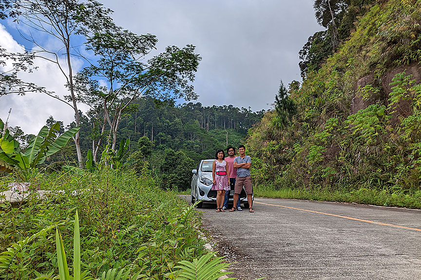 Family picture in the middle of nowhere, in the forests of Barangay Rogongon along the Iligan-Bukidnon road. 17 April 2022. MindaNews photo by BOBBY TIMONERA
Maybe I can bring Thurber (yep, the Wigo has a name) up the forests of Rogongon? But it’s a small car, with low ground clearance.
We will likely encounter muddy roads in Rogongon. The first week of April brought heavy rains. Why even the street in front of our house was flooded and quickly turned into a river.
Maybe we could try instead the new highway passing through the mountains of Claveria in Misamis Oriental. Or, if we’re not up to a very long drive, maybe enjoy the mangrove reserve of Laguindingan. Or up the highlands of Manticao where my running group often went, and where a friend recently built a weekend house.
But the fates smiled on us at last and there was no rain at all during the entire Holy Week. True summer weather!
On Black Saturday, I asked a few people I thought had passed through the Iligan-Bukidnon road if the Wigo could get through. The usual answer was, nope, please don’t dare. I tried calling Gigi of MindaNews, hoping he’d change his mind about the car’s ground clearance, but he was unreachable at that time.
Now two people that I know who are very familiar with the route – Ombay Cabasa of the Sikyop Agri-Tourism Adventure in Rogongon, and offroad warrior Waway Estillore, who did the nature-themed infra developments at Sikyop and who often organizes 4×4 expeditions in Mindanao’s forests – said the Wigo can handle the terrain. It’s mostly paved anyway, just drive slow on the rough roads, they said. There had been no rain up there for days, Ombay reported, adding that in the most recent landslide, he drove only a Multicab.
So before we went to bed, I told my wife and my son: Let’s try Rogongon tomorrow. If it rains, we’ll make a U-turn and go somewhere else.
Beautiful drive
I’m not worried about a landslide, because the plan was just to head back if there’s one blocking the road. We prayed we won’t be the unluckiest of people who’d get buried in the mud and debris. But what if there were multiple landslides and we’d get trapped in between that we may have to spend a night or two in the forest?
So we prepared for eventualities: we carried enough water to last two days, food good for four meals, flashlights, jackets, three huge power banks, phone chargers, a 12VDC-to-220VAC power converter, a 12V tire inflator. And gassed up a full tank on our way out.
The sky was overcast when we started the drive. That worried me a bit, but then, we’ve decided to drive back in case it rains. So off we went.
Such a beautiful drive it was. Even along the paved roads, we drove slowly, enjoying the green scenery. We turned the aircon off, rolled down the windows, and breathed in the cold air.
On a long bridge traversing a ravine (location: 8°13’34.6″N 124°25’15.5″E), we were so enthralled with the thick forest on both sides of the road. So we got off, walked to the middle of the bridge, and took our pictures. That’s about 27 kilometers from the highway in Iligan, and two kilometers past the Rogongon barangay hall.
We stayed on the bridge for a few minutes as Miriam and Arkay sang tunes from “Jesus Christ, Superstar,” which we watched on Good Friday.
As we resumed the drive, things started to get a little scary. There was a series of landslides as we passed by curved roads in the next two kilometers. I was still comfortable, still able to take pictures using my phone while driving.
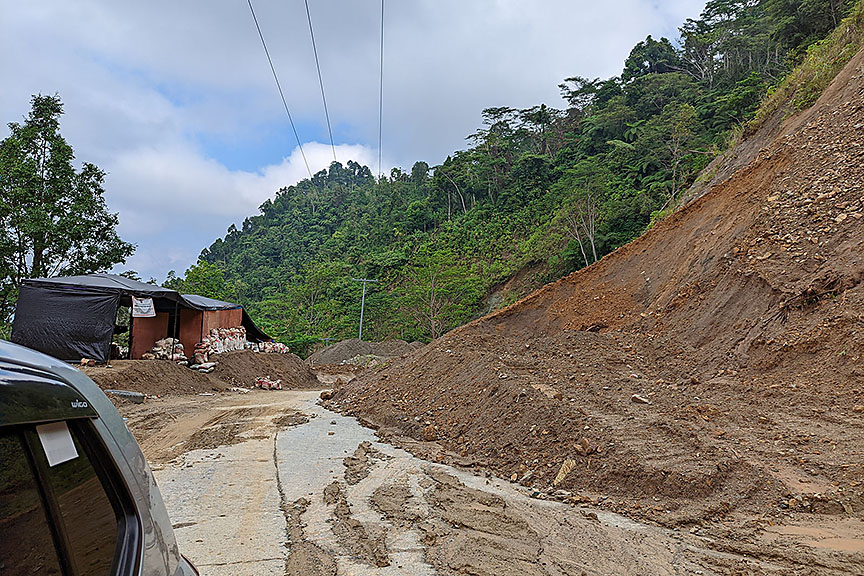 The view past the scary landslide somewhere in Rogongon. 17 April 2022. MindaNews photo by BOBBY TIMONERA
But towards the end (8°13’13.7″N 124°26’04.9″E), I tensed. On my left was a huge mountainside already carved out, a large amount of soil deposited on the road. It’s just mostly mud, no big rocks. Although the two-lane road is paved, ahead of me was a 100-meter narrow passageway just enough for one car. Anytime, the mud could roll down the road, maybe even with just slight rain.
The photojournalist in me disappeared. All that was in my mind was my family’s safety, how to get past the landslide area as soon as possible, even though I was driving so slowly, holding my breath, both hands firmly gripping the wheel, eyes focused on the road.
Just drive on
I breathed a sigh of relief only after passing that scariest part. I stopped and asked a man in civilian clothes carrying a long firearm: “Daghan pa’y ing-ani? Makalusot ra mi paingon Talakag?” (Are there more of these landslides? Can we get to Talakag?) He was a CAFGU, I suppose.
He looked amazed at our little Wigo and replied: “Mao na man ni’y pinakagrabe. Padayon lang, ok ra mo.” (This is the worst. Just drive on, you’ll be ok.)
Only then did my photojournalist mindset come back. I engaged the handbrake, my right foot still stepping on the brake on this uphill road, craned my neck out the window, and took pictures of what was behind us. But we were already past the scariest part.
As we continued with the drive, now relaxed, I told Arkay we missed one great photo
opportunity. I should have told him to get out of the car, run up front, and take pictures of the mountainside that caved in, using a wide-angle lens, the little Wigo showing towards the edge. That would have been one magnificent, albeit scary, picture. That would make Toyota proud.
“No, Pa, we shouldn’t do that. Safety is our first concern.”
He was right, of course. But had I been out on coverage, not me on the wheel, I’m sure that’s what I’d do.
The man with the long firearm was right. There were some landslides ahead, but not of that magnitude. There were a few kilometers of rough roads, some big muddy potholes, but nothing that the Wigo can’t handle. I had to stop a few times and get down the car to inspect the road. Once I’d confirmed that it was all mud and no big rocks protruding that would damage the car, I continued with the drive. I could feel the soil scratching the Wigo’s under chassis, but there was no worrisome sound.
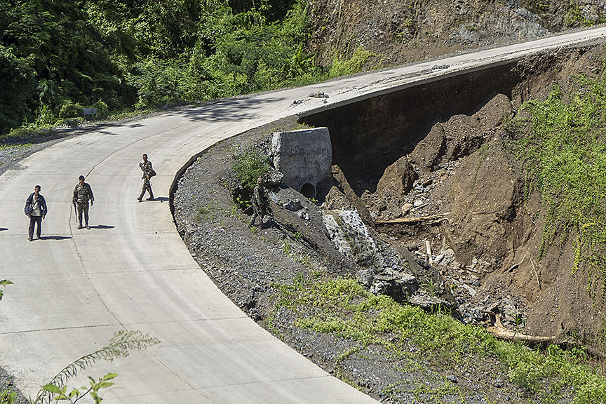 Another hazard in the Bukidnon-Iligan road: concrete pavements with no more soil support underneath. Photo taken November 2015. MindaNews photo by BOBBY TIMONERA
Yet another hazard are portions of the paved roads with the soil beneath already gone, damaged by water during strong rains I suppose, and a ravine beside it. Imagine if it collapses with the car’s weight. What I did was to drive on the inner side, even if I was on the wrong lane.
Rolling hills and corn plantations
We stopped again when we saw a beautiful spot about 10 kilometers from the landslides. I set up the tripod and took our picture, which I posted on Instagram and Facebook the next time we reached a spot with a good phone signal, just before we reached the boundary with Talakag. It was in this latter location where we stopped for merienda, enjoying our homemade corned beef sandwich as our eyes feasted on the scenery of rolling hills and corn plantations.
Less than a kilometer later, we stopped at a fork in the road, not sure which to take. I consulted Google Maps on my phone, which told me that going left was the shorter distance to the highway via Lantud. I decided on this seven-kilometer route, against going right passing by Limunsodan Falls that’s a 15-kilometer drive.
As I was about to start the car again, a Multicab stopped beside me and the driver asked in the vernacular: “You okay, Sir? You’re heading where?”
“Is this the way to Talakag?”
“Yes. Upon reaching the highway, turn left to the poblacion, and right if you’re heading to Valencia. Just follow me.”
Since we’re heading back to Iligan via Talakag and Cagayan de Oro, I followed his advice.
But what I thought was a short seven-kilometer drive felt more like 40. I found myself driving on one of the roughest roads I’ve ever encountered, a limestone road with huge stones protruding. It was like playing patintero avoiding all those big stones, except that I was driving as slow as I could, mostly at 10kph.
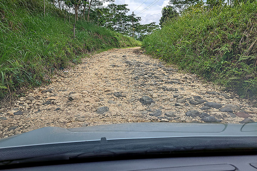 The rough roads of Barangay Lantud in Talakag, Bukidnon. 17 April 2022. MindaNews photo by BOBBY TIMONERA
At least there was no danger of getting stuck in the mud, and the view of the corn and pineapple plantations was beautiful that I had to stop a few times to take pictures with my phone.
Had I taken the 15 km route, I’m sure we’d get to the highway faster. I was told there are fewer unpaved roads there, so I’d probably reach the highway in half the time.
When we reached the highway, at the intersection where a military detachment stands, I asked Arkay to get down the car and take pictures, as proof of life.
The remaining 145-kilometer drive toward home was smooth, passing by a Jollibee drive-through near SM Uptown for a smoothie, then lunch by the beach near the mangrove reserve in Tubajon, Laguindingan.
So, would I drive the Iligan-Bukidnon road again? Would I recommend it to other people?
It depends.
If you want a faster way to get to Bukidnon or Davao from Iligan in the rainy season, I suggest you go via Cagayan de Oro instead. Via Lumbia and Talakag would be your surest and safest option. If there’s a landslide in Rogongon, you’d waste precious hours or, worse, get trapped in the mountains.
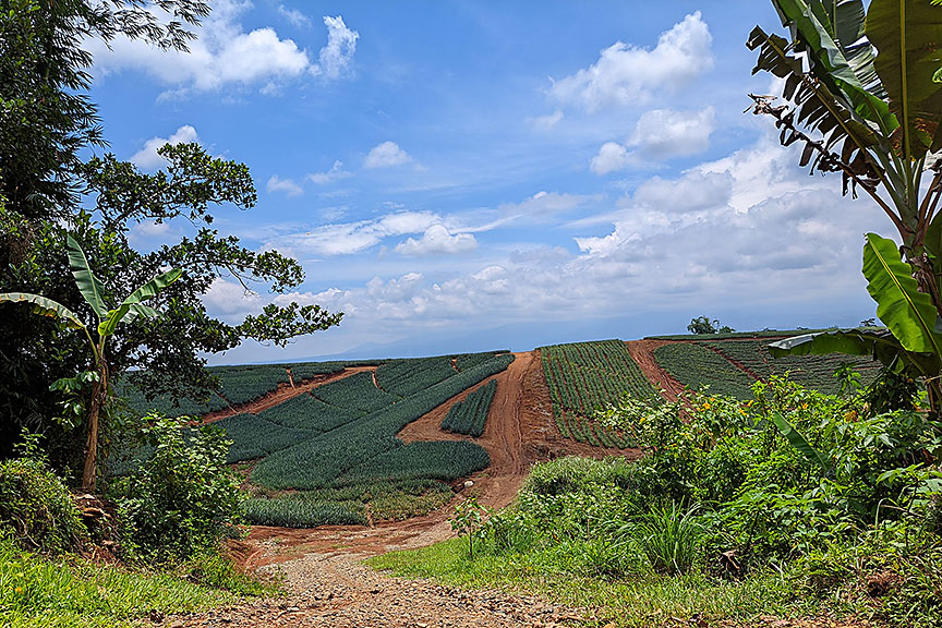 Beautiful pineapple plantation in Talakag, Bukidnon. 17 April 2022. MindaNews photo by BOBBY TIMONERA
4×4 or ordinary vehicle
Remember Waway, who gave me advice to push through with our drive on a Wigo? He’s very familiar with the terrain, he drives a 4×4 pickup truck, he’s been driving through the country’s roughest terrains, but still, on a rainy day more than a week after our trip, he got trapped with a fallen tree during a landslide. “Careful driving through these critical areas because the soil is not stable. I know the area well, but still got unlucky,” he advised.
If you’re just after an adventure like us, with no particular destination or no time constraints, sure! Just don’t go up there if there have been rains the past few days, and no rain the day of your trip.
I can say it doesn’t matter if you have a 4×4 or an ordinary vehicle. Just go slow on the rough roads and you and your car will be okay. Just make sure your car is in tiptop shape, well maintained, not too old, and hasn’t had a breakdown lately. My friend Jingle, who owns the auto shop that’s been maintaining our cars for over a decade, told me you’re not supposed to bring a Wigo up there. He is familiar with the terrain because he is also a pastor who leads a church in Rogongon.
Take note that in most parts of the road in Rogongon, there’s no cell phone signal, no Globe or Smart. So when your car breaks down, good luck. We met a handful of motorcycles on the road, though, and three four-wheel vehicles. Jingle said people there are very helpful. If you look at Google Maps, there are only a very few houses past the populated portion of Rogongon.
Maybe it will help if you listen to the news, or ask people you know who are familiar with the place. After I posted that family photo, a friend sent me a message asking if we were safe, if we’d already reached Bukidnon. Because he learned there was a clash between government soldiers and communist rebels recently, the reason a major biking event headed for Rogongon was moved elsewhere. Or maybe it was for the better we didn’t learn about the news, because otherwise, we wouldn’t have pushed through with the drive?
Jingle said there was a red alert in the area because of the presence of the New People’s Army. Farmers are allowed to be on their farms only two hours in the morning and two hours in the afternoon.
A few years back, there was news of the Moro Islamic Liberation Front setting up camp in Rogongon, prompting the military to dismantle it.
And so my final answer: Yes, I’d drive it again. But maybe next time, in a convoy of two or more vehicles. So when one car breaks down, you can still proceed with the drive. (Bobby Timonera / MindaNews)
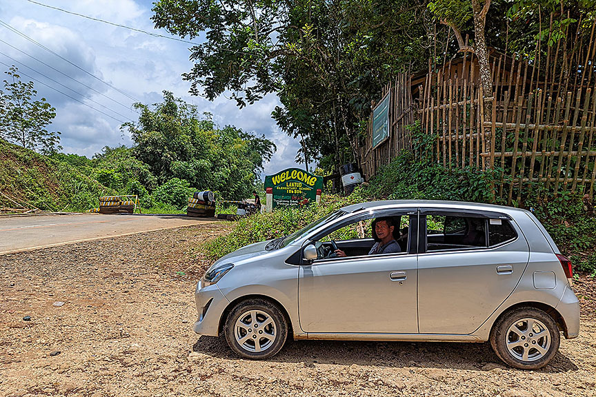 We made it! At the end of the Iligan-Bukidnon road, reaching the highway in Talakag, Bukidnon. 17 April 2022. MindaNews photo by ARKAY TIMONERA
Note: You can follow the route here. – https://onthegomap.com/s/iej9qbrd
